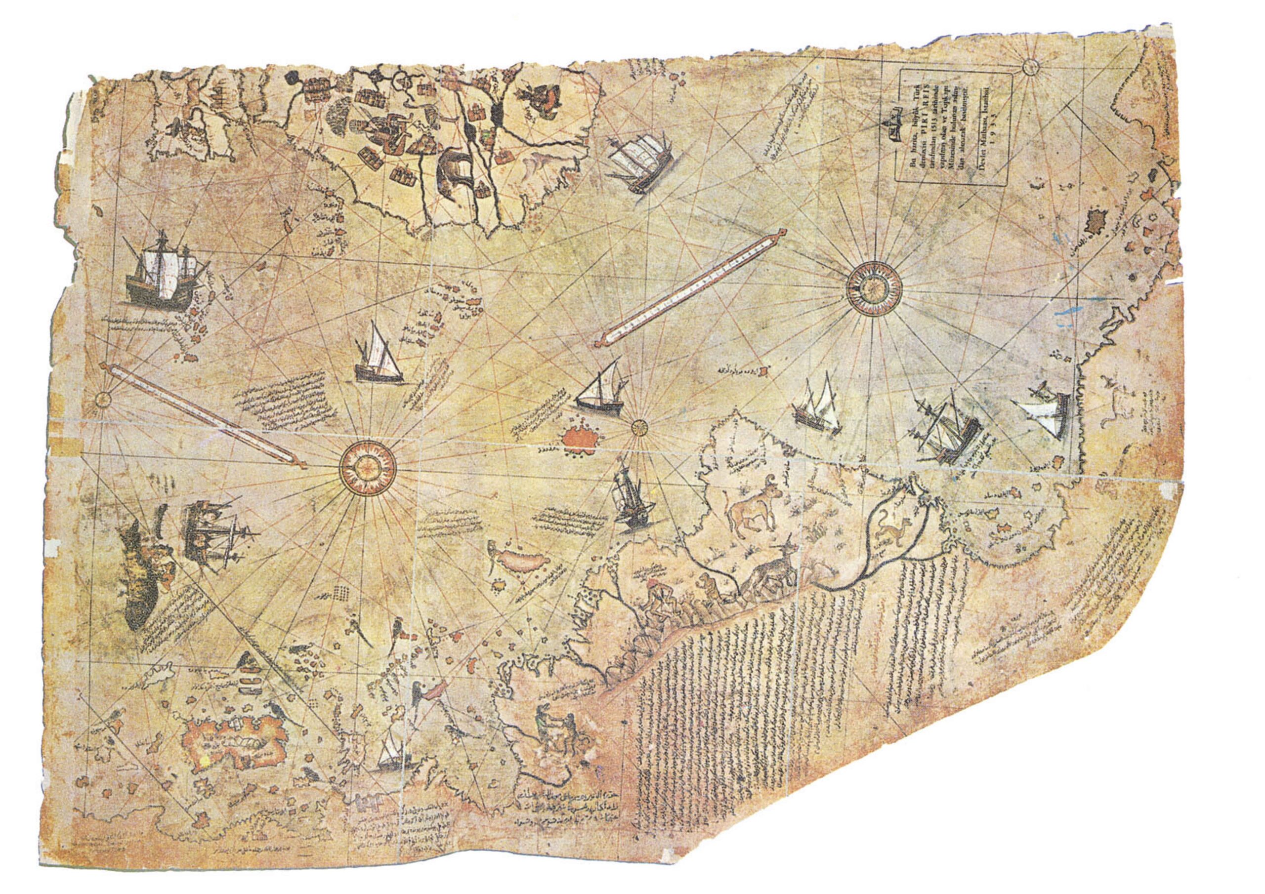
Piri Reis Map (Image Credit: Library of Topkapı Palace Museum, No. H. 1824 Bilkent University)
Introduction to the Piri Reis Map
The Piri Reis Map is an artifact that has attracted the attention of historians, archaeologists, and adventurers. The map was signed by Piri ibn Hajji Mohammed Reis (Reis being a rank akin to a naval captain). Named after Piri Reis, this ancient map is believed to be over 500 years old and provides some information about a world that is both familiar and mysterious.
Historical background of the Piri Reis Map
The Piri Reis Map was discovered in 1929 in the Topkapi Palace in Istanbul, Turkey. It is believed to have been drawn by Piri Reis in 1513, only 21 years after Christopher Columbus had reached the New World, predating many other maps of the time. What makes this map truly remarkable is its level of accuracy and detail. The map depicts the coastlines of South America, Africa, and Antarctica with incredible precision, even though Antarctica was not officially discovered until the 19th century. This raises questions about the knowledge and technology available to ancient civilizations.
The mysteries surrounding the Piri Reis Map
One of the biggest mysteries surrounding the Piri Reis Map is how it accurately portrays the coastlines of Antarctica. The map shows the continent as it looked during the Neolithic Era (a.k.a. New Stone Age, which existed around 7000–1700 BCE.) without ice covering it, suggesting that the cartographer had access to only recently discovered information. Some theorists believe the map is evidence of an advanced ancient civilization that possessed knowledge far beyond what was previously thought possible. Another theory is that the map may have been based on older source maps that have since been lost, which is even more mysterious because that would mean that this knowledge might be even older than the cartographer of the map. Maybe there was a genius caveman adventurer who could draw with such precision in stone! Who knows? Whatever the case, the Piri Reis Map shows how much we do not know.
Analysis and interpretation of the Piri Reis Map
Researchers have examined the Piri Reis Map using various techniques, including satellite imagery and computer analysis. These studies have revealed that the map is remarkably accurate, with coastlines that match up with modern maps. Some of them say that this level of precision is too advanced for the period in which the map was created, leading to further questions about its origin and purpose. It is possible that it was created by extraterrestrial beings who visited Earth in ancient times. Or rather, Piri Reis had access to their knowledge one way or another. This knowledge might be connected to aliens or an ancient race like the Atlanteans and Lemurians. The connection between the Piri Reis Map and theories about Atlantis arises because of certain features on the map. Some individuals and fringe theories propose that the map contains information about Atlantis, even though the mainstream scholarly community does not support such claims. The primary source of this speculation comes from the representation of the coastline of South America, particularly in the region of the Caribbean, which might be interpreted as corresponding to elements of Plato’s description of Atlantis. It’s important to note that the Piri Reis Map was created in the early 16th century, while the “concept” of Atlantis comes from the emerald tablets written by Thot the Atlantean and also from some of the ancient Greek texts.
Other Ancient Maps and Their Significance
While the Piri Reis Map is undoubtedly remarkable, it is not the only ancient map that has raised the interest of historians and researchers. Throughout history, there have been numerous maps that have shaped our understanding of the world. The Orontius Finaeus Map, for example, similarly depicts Antarctica as the Piri Reis Map, suggesting a shared source of information or a common cultural belief. The Vinland Map also provides evidence of Viking exploration of North America long before Columbus. All ancient maps, including the Piri Reis Map, offer a glimpse of human history and the untold stories of those who came before us.
Conclusion of the Piri Reis Map
The Piri Reis Map remains mysterious. Whether the map was based on older sources, influenced by extraterrestrial knowledge, or a product of advanced 16th-century cartography, its significance cannot be denied. Its accuracy and level of detail, including the mysterious Antarctic coastline, defy the conventional wisdom of its time and change our understanding of ancient times. While its authenticity may be contested, the map stands as an important historical artifact that encourages further study and exploration. If you happen to look at an ancient map, just think about the possibly incredible journey that has led to its creation and the endless possibilities it represents.
